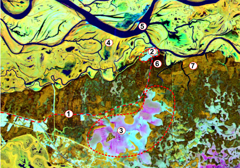
The field station in Shapsha village is located 24 km East of the city of Khanty-Mansiysk and serves as a permanent base for scientific research.
Geographical coordinates: 61.08764N, 69.459206E
Logistics: You can get from the city to the station in Shapsha by regular shuttle bus (runs 7 times a day).

1 — the road to Khanty-Mansiysk (20 km), 2 — the village of Shapsha, 3 — the raised bog «Chistoe», 4 — floodplain meadows of different levels (low and medium levels, floodplain shrubs and forests), 5 — the Ob River channel «Gornaya», 6 — dark coniferous forests, 7 — deciduous forests.
The educational and laboratory complex of the station is equipped for organizing and conducting research, summer schools, seminars and meetings. In the laboratory building with an area of 400 sq.m., are located:
- Gas chromatography laboratory
- Geosystem research laboratory
- Biological collection of the Yugra University
- Fungarium — collection of fungi
- Library
- Kitchen
The village is located on the high bank of the terrace of the Ob river. From the south, the village is surrounded by typical dark coniferous (cedar) and mixed mid-taiga forests, alternating with areas of open and treed bogs. An extensive Ob floodplain about 30 km wide extends to the north, represented by flood meadows, numerous floodplain ponds, channels and narrow strips of forests.
About 550 inhabitants reside in the village permanently. The landmark of Shapsha is a natural protected area “Samarovskiy Chugas” with a small zoo and educational ecological center.
Look at some of Shapsha field station views in our album:
